.png?width=680&height=1008&name=pole-no-bg%20(1).png)
.png?width=500&height=500&name=Release%20Notes%20Template%20(1).png)
v26.8 Katapult Pro Release Notes - Featuring Workflow Management and Configurable Proposed Cable Logic!
You have a few thousand poles to survey, a client expecting deliverables on a deadline, and FCC timelines that keep getting shorter. The survey is the first real step, and almost everything downstream depends on how well it goes. Get clean, accurate, defensible data back from the field and the rest of the project has something solid to build on. Get incomplete or questionable data and you are looking at rework, disputes, and a construction date that keeps sliding.
The utility pole survey is the part of the workflow that quietly determines how the whole project runs. It rarely gets the attention that make ready or pole loading gets, but the make ready calls, the loading analysis, the permit sheets, and the attachment records a joint use team relies on for years all inherit the quality of what came back from the survey.
This guide covers what a utility pole survey actually is, the scopes it feeds, how a modern photo-based survey runs in the field and the office, how fast it can realistically go, and what to look for in the software and the partner behind it. If you are responsible for getting a high-volume survey done right, the sections on process and throughput are where the practical decisions live.
For teams that want to see the data foundation in action, here is how Katapult Pro's data collection tools support pole surveys from the field up.
What is a utility pole survey?
A utility pole survey is the process of collecting accurate, defensible field data about utility poles and everything attached to them, so that data can drive engineering, permitting, and asset decisions. In practical terms, a survey captures where each pole is, what is on it, at what heights, and in what condition, and turns that into a record other teams can act on.
The specifics vary by scope, but a survey typically captures pole locations and the connected infrastructure around them, the attachments on each pole and their heights, the equipment present such as transformers or capacitor banks, the condition of the pole and its hardware, and the identity of each attacher. That record becomes the single source of truth for the work that follows.
Traditionally this data was gathered with a measuring wheel, a hot stick or laser rangefinder, and a clipboard or tablet, with the office team later re-entering everything into permit forms and loading software. Modern photo-based platforms changed that by letting field crews document conditions with calibrated photographs and letting the office extract measurements from those photos later. The result is a survey that moves faster, keeps crews out of the power space, and leaves behind a defensible photo record of every pole.
The important thing to understand is that a survey is not an end in itself. It exists to feed the scopes that depend on it.
What a pole survey feeds
A single well-run survey can serve many downstream scopes, which is exactly why survey quality matters so much. The same dataset, collected once, can support several of the following.
Pole attachment permitting. When a communications provider wants to attach to a utility's poles, the survey provides the existing-conditions data the attachment application and engineering review depend on. Clean survey data keeps the pole permitting process moving instead of stalling on disputes about what is actually on the pole.
Make ready engineering. Before a new attachment goes up, engineers determine what work the pole needs to accommodate it safely. That analysis runs on survey data, and make ready engineering is only as reliable as the field record behind it.
Pole loading analysis. Determining whether a pole can safely carry its existing and proposed load requires accurate heights, spans, equipment, and pole attributes. A survey collects the inputs that pole loading analysis needs, whether the analysis happens in an external platform or inside the survey software itself.
Joint use management. For pole owners, the survey feeds the attachment records and inventory that a joint use program relies on to track who is on which poles and under what terms.
Distribution inventory and audits. Surveys also support asset inventory, double wood surveys, telecom audits, and post-construction inspection, all of which need an accurate picture of current field conditions.
Because one survey can serve all of these, the cost of getting it wrong compounds. A gap in the field data does not affect one deliverable. It affects every scope that inherits from it.
Planning a high-volume pole survey
The work that determines whether a survey goes smoothly happens before the crew ever leaves the office. A high-volume survey that starts without a clear scope and route tends to produce inconsistent data, repeat field trips, and a processing queue full of questions the crew is no longer on site to answer.
Scope definition comes first. The team needs to agree on exactly what gets captured at each pole, from the attachments and equipment down to the specific reference photos, so the dataset serves every downstream scope the project will need. Deciding this up front is what lets a survey collected once feed permitting, make ready, and pole loading without a second trip. A survey scoped narrowly for a single deliverable almost always has to be redone when the next scope needs data that nobody thought to capture.
Route planning comes next. Mapping the collection route ahead of time keeps a crew moving efficiently and makes sure no pole gets skipped, which matters most on large jobs where a missed pole is not discovered until office processing weeks later. A pre-planned route on a mobile device also lets the crew mark each pole and midspan as complete, so progress is visible and gaps are caught while the crew can still fix them.
Crew readiness rounds it out. Because a photo-based survey depends on calibrated, consistent images, a crew that understands the calibration discipline and the standard shot list produces data the office can trust on the first pass. The planning investment is small compared to the cost of sending a crew back out because the first pass came home incomplete.
How a modern photo-based pole survey works
A modern survey separates field measurement from office processing, which is the single most important design decision behind how these workflows scale. Understanding the two halves explains why photo-based collection moves faster than traditional methods.
In the field
A two-person crew moves through a pre-planned route, documenting each pole with calibrated photographs from the ground. One crew member handles the height and context photos and confirms the route on a mobile device, while the other captures the close detail shots of tags, hardware, grounding, and other references, and holds a calibration stick at the base of the pole so heights can be extracted later. Two people moving as a coordinated unit is what lets a crew clear poles quickly without missing anything, because no single person is trying to frame a height shot, read a birthmark, and track map progress all at once.
Collecting from the ground keeps crews out of the power space, which removes a serious safety exposure from routine work, and it means less experienced crews can gather reliable data while senior engineers stay focused on design. This is the heart of the Katapult Method, a photo-based workflow refined over decades of OSP practice, and there is a deeper look at why the data still lives at the pole in the utility pole field data collection guide.
In the office
Once photos are uploaded, the office team extracts the engineering data from them. That includes classifying photos, measuring attachment and equipment heights, tracing cable ownership, calling make ready, and running pole loading analysis. Because the work is photo-based, engineers do this without returning to the field, and disputes about what was on a pole get resolved by looking at a dated, geolocated, measurement-calibrated image rather than sending a crew back out.
Many teams split office processing into an assembly line, so less technical staff handle the simpler classification and measurement steps while more experienced engineers focus on make ready calls and loading analysis. That division of labor is what lets a firm scale output without putting every task on its most senior people.
How fast can a pole survey go?
Speed matters more than it used to. With FCC pole attachment timelines as short as they are, the pace at which pole data gets collected, processed, and delivered has a direct effect on when a project reaches construction.
Katapult's own methodology gives a sense of realistic throughput. In the field, a two-person team collects between 100 and 200 poles in a single day, depending on the scope of work. Full-stack processing takes longer, because it is where the engineering judgment happens: an office staff member can classify photos, measure attachment and equipment heights, trace cable ownership, call make ready, and perform pole loading analysis on roughly 30 poles in a work day. Splitting those office responsibilities across an assembly line raises total throughput by letting each person work at the level that fits their experience.
The takeaway for planning is that field collection is rarely the bottleneck. Office processing is the slower half because it carries the engineering, which is another reason accurate field data matters: the cleaner the data coming in, the faster the office can turn it around without chasing gaps.
Have a high-volume survey and a deadline that will not move?
The right platform lets a small field crew collect fast and gives your office team the tools to process without rework. Katapult Pro is built for exactly this workflow, from field collection through make ready and loading exports.
Software and tools for pole surveys
The tooling behind a pole survey spans field collection, office processing, and the loading and permitting platforms the data eventually flows into. Understanding how these pieces fit clarifies what to look for.
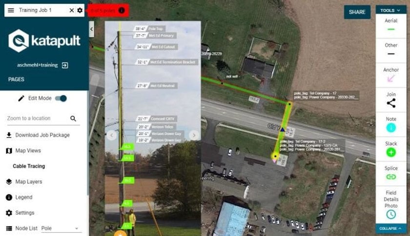
At the collection layer, a survey platform needs to capture calibrated photos and field data reliably from the ground, keep that data in a live system the office can see immediately, and support the standard scopes a team runs without forcing a different workflow for each one. At the processing layer, the platform needs tools to extract heights, trace ownership, flag violations, and call make ready against an accurate model. And at the analysis layer, the data has to move cleanly into whatever pole loading software the project requires.
This is where a platform like Katapult Pro fits. Rather than replacing the loading software a team already trusts, Katapult Pro focuses on the collection and processing foundation and exports cleanly to the tools each project needs, including SPIDAcalc and O-Calc Pro. It also includes an integrated pole loading engine for teams that want real-time loading results while they call make ready, without leaving the platform. The point is flexibility: a survey collected once should be usable across every downstream scope and every loading tool, without re-collection or format wrangling.
Because the data stays connected from field photo through make ready call to final deliverable, the same survey can produce permitting sheets, pole profiles, map sets, or custom exports at the click of a button, with each deliverable traceable back to the original photo documentation.
See how Katapult Pro supports the full survey workflow from collection through delivery.
Surveys, applications, and joint use
For pole owners, a survey is also the entry point into managing third-party attachments at scale. When a comprehensive system curates and manages the pole database and also handles online attachment applications, joint use becomes far less of a manual burden.
A modern approach connects the survey to the application itself. A submitted attachment application can seed the job data that kicks off field collection and make ready engineering, survey data and make ready decisions become visible to all parties through a shared portal, and the same record can trigger post-construction inspections once work is done. That transparency is what keeps pole owners, attachers, and contractors working from the same facts instead of arguing over diverging spreadsheets, and it supports one-touch make ready, which is now an established part of the attachment landscape rather than a future possibility.
If your survey data lives in a system that also runs your joint use management and application workflows, the survey stops being a one-time deliverable and becomes the living record your attachment program runs on.
Common pole survey mistakes and how to avoid them
Even experienced teams run into the same recurring problems. A few are worth naming.
Treating the survey as a low-stakes step. Because the survey happens before the visible engineering work, it is easy to under-resource it. Every scope downstream inherits its quality, so a rushed or incomplete survey is one of the most expensive mistakes a project can make.
Collecting for a single scope. A survey collected narrowly for one deliverable often has to be redone when the next scope needs data that was not captured. Collecting to a standard scope that serves permitting, make ready, loading, and inventory at once avoids repeat field trips.
Skipping calibration discipline. Photo-based surveys depend on calibrated images to extract accurate heights. A crew that gets sloppy with the calibration stick or the height shots produces data the office cannot trust, which forces field revisits.
Separating collection from processing tools. When teams collect in one tool, process in another, run loading in a third, and compile deliverables in a fourth, every handoff invites data loss and version confusion. Keeping the survey on one connected platform removes those seams.
Sending senior engineers to do field collection. Putting the most experienced staff in the field to collect data wastes the expertise that adds the most value in the office. A ground-based photo workflow lets less experienced crews collect reliably while engineers focus on the calls that require judgment.
Ignoring defensibility. Survey data gets challenged, especially in permitting and make ready disputes. A survey that leaves behind dated, geolocated, calibrated photos of every pole gives a team a record that holds up when a utility, an attacher, or a federal reviewer asks what was really on the pole.
Frequently asked questions about utility pole surveys
What is a utility pole survey? A utility pole survey is the process of collecting accurate, defensible field data about utility poles and their attachments so that data can drive engineering, permitting, and asset decisions. It captures where each pole is, what is attached at what heights, what equipment is present, and the condition of the pole, creating a record the downstream work depends on.
What data does a pole survey collect? A survey typically captures pole locations and connected infrastructure, attachment heights, attached equipment such as transformers and capacitor banks, pole and hardware condition, and the identity of each attacher. The exact fields depend on the scope, but the goal is a record complete enough to serve permitting, make ready, and pole loading from a single collection.
How long does a pole survey take? Field collection is usually the faster half. Using a photo-based method, a two-person crew can collect between 100 and 200 poles in a day depending on scope. Full-stack office processing, which includes measurement, make ready, and loading analysis, runs closer to 30 poles per person per day because it carries the engineering work.
What is the difference between a pole survey and a pole audit? The terms overlap. A survey is the general collection of pole field data that feeds engineering and permitting, while a pole audit usually refers to inventory-focused efforts such as verifying attachments, checking for unauthorized attachers, or confirming asset records. The same photo-based collection workflow can support both.
Who needs a utility pole survey? Utilities and pole owners need surveys for inventory, joint use management, and their own construction. Communications and fiber providers need survey data to submit attachment applications and move through make ready. OSP engineering firms run surveys as a core service for both groups.
Do I have to enter the power space to collect survey data? No. A photo-based, ground-level method lets a crew document poles from the ground using calibrated photographs, which keeps crews out of the power space and removes a significant safety exposure while still producing the measurements the office needs.
Can survey data be used in SPIDAcalc, O-Calc, or PoleForeman? Yes. A well-built survey platform exports cleanly to the major pole loading tools, so data collected once can feed whichever loading software a project requires. Some platforms, including Katapult Pro, also offer an integrated loading engine for real-time results during make ready.
How do I keep survey data defensible? Capture dated, geolocated, measurement-calibrated photos of every pole and keep them connected to the extracted data. That photo record lets teams resolve disputes by reviewing the image rather than sending a crew back to the field.
Ready to run your next pole survey on data you can trust?
A utility pole survey is the foundation the rest of your project stands on. The permitting, the make ready, the pole loading, and the attachment records your team relies on for years all inherit the quality of what came back from the field. Done well, the survey produces fast throughput, keeps crews safe, and leaves behind a record that holds up under scrutiny. Done poorly, it produces the rework and disputes that quietly erode margin and push construction past its deadline.
The right data collection, processing, and engineering tools let a small field crew move fast while your office team turns clean data into deliverables without re-collection. That is the workflow Katapult Pro was built for, and it is the same workflow Katapult's own engineering services teams run every day.
Schedule a call with our team to see how Katapult Pro can support your pole survey, make ready, and pole loading workflows. Get started here.